By Allison Campbell-Jensen
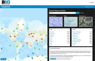
Data about COVID-19 and much, much more can be accessed via the Big Ten Academic Alliance Geoportal, hosted by the U of M Libraries
The public emergency of the COVID-19 pandemic caused The Big Ten Academic Alliance Geoportal to move fast. The day following a call for COVID-related data from the geoportal’s collection development committee, says Karen Majewicz, the U of M Geospatial Project Metadata Coordinator, “data started to come in.”
While the collection development policy for the project is rather strict about making sure that data fits certain access criteria, in the case of COVID-19, Majewicz says, “we loosened our workflow a little bit.” The decision was made to tell members of the consortium “to send in whatever you think is important and useful.”
Now, insights can be gleaned from such timely resources as the Minnesota COVID-19 dashboard, which is regularly updated, and other state-based data. Yet the BTAA Geoportal offers much more, as more than 9,000 users discovered last year.
Defining, combining geospatial data

Ryan Mattke
Before delving further into this geoportal, a definition of what data it accesses may be helpful.
“Geospatial data combines location information (usually coordinates on the earth), attribute information (the characteristics of the object, event, or phenomena concerned), and often also temporal information (the time or life span at which the location and attributes exist),” according to a Science Direct article.
Or, as Madeleine J. Kerr, Associate Professor Emerita in the School of Nursing, puts it: “Everything happens somewhere.”
The BTAA Geoportal is a search tool for GIS datasets, web services, and digitized historical maps from multiple data clearinghouses, and library catalogs. Most geoportals are operated by a single institution, says Ryan Mattke, the U of M’s Map & Geospatial Information Librarian, but this project uniquely facilitates access among a group of 13 member institutions, with the U of M Libraries hosting the BTAA Geoportal.
The BTAA Geoportal includes: University of Chicago; University of Illinois at Urbana-Champaign; Indiana University Bloomington; University of Iowa; University of Maryland; University of Michigan; Michigan State University; University of Minnesota (host institution); University of Nebraska-Lincoln; Ohio State University; Pennsylvania State University; Purdue University; and University of Wisconsin-Madison.
Not only are they connected geographically, stretching from the Midwest to the Eastern Seaboard, they also “are doing what we can to leverage resources,” Mattke says, “so that everyone can benefit.”
Data-based projects: Far-reaching and nearby
A geospatial project’s reach can be worldwide, such as EarthStat, which was created to support researchers developing ways to feed a growing world population while reducing the environmental impact of agriculture. National Geographic, among other entities, has used the data in illustrative maps. EarthStat is a collaboration between the Global Landscapes Initiative at the University of Minnesota’s Institute on the Environment and the Land Use and Global Environment Lab at the University of British Columbia, with assistance from Stanford University.
Closer to home, after Kerr had met Majewicz at a GIS Day on campus, she decided to offer nursing students in a continuing education course the opportunity to work with the Geoportal’s data. Majewicz created a tutorial for the students, who were successful in using the BTAA Geoportal to create their maps.
Geospatial knowledge is important, Kerr says, because “your health should not be determined by your ZIP Code.” She taught her nursing students that individuals’ behaviors should not be separated from the social determinants of health: “Your health has a lot to do with where you live and where you work.”
Challenges to access
To offer access to a great variety of data from many sources, one must align the metadata, so all datasets are translated into the same language, so to speak. That was one challenge noted in a Collaborative Librarianship article, “A Spatial Collaboration: Building a Multi-Institution Geospatial Data Discovery Portal,” authored by Mattke, Majewicz, Mara Blake from Johns Hopkins University, and Kathleen Weessies of Michigan State University.
Initially, those involved in creating the BTAA Geoportal envisioned an automated way to meld the metadata descriptors of datasets and maps. But they found it necessary to have staff available to manually intervene so that datasets could relate to each other with common subject terms and date formats, helping researchers harvest data effectively. The task has been substantial: The BTAA Geoportal launched in August 2016 with more than 2,600 metadata records describing datasets and scanned maps; in a little more than a year, that grew to 7,500 metadata records.
Moreover, while learning to work as a consortium, the members quickly found that managing the data was challenging. After envisioning using cloud-based storage, they decided on a different solution; fortunately, the authors write, “the University of Minnesota Libraries’ Web Development Department stepped up and became a solid project partner.” The U of M Libraries’ web developers also contributed to a greatly improved user interface.
The first data collected by the BTAA Geoportal members were their state governments’ GIS files and scanned maps in their collections. While many geoportals create a repository, what Majewicz calls “more of a static catalog,” the BTAA Geoportal is different. She and colleagues across the consortium emphasize providing access to the most current information. She says: “Every month we are collecting new resources.”
The task force members meet in regular meetings monthly and less formally much more often to share tips on how to approach public sector GIS employees, how to find lesser known sources of data, and how to address issues in workflows or with the open-source GeoBlacklight platform upon which they rely.
Geospatial collaboration benefits
As a result, the Big Ten geospatial librarians and specialists now are more closely connected. Their work also has made them leaders beyond the BTAA Geoportal, as they guide development of the GeoBlacklight platform, publish workflow documentation now being widely used, and consult with other institutions.
With the May 2020 addition of the University of Nebraska-Lincoln, the BTAA Geoportal continues to expand its reach. To sum up the consortium’s accomplishments in one way, the BTAA Geoportal has “[a]ggregated, enhanced, and normalized metadata records for over 30,000 publicly available resources into a single search portal — [which] includes geospatial data, as well as scanned maps from library collections.”
More usefulness has resulted in more users; their number increased by 25% in the last year.
Kerr sees great progress since her nursing class used the BTAA Geoportal in 2018. She says: “I think it is just getting better and better and more expansive in the types of data they host.”


