By Allison Campbell-Jensen
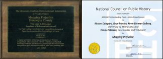
 On March 15, the Libraries’ Mapping Prejudice project and Hennepin County jointly received the 2021 John R. Finnegan Freedom of Information Award from the Minnesota Coalition on Government Information. Finnegan was a journalist who became editor and publisher of the St. Paul Pioneer Press.
Through the partnership between the project and the county, volunteers have been able to access property deeds to identify racially restrictive covenants. These covenants barred future owners from selling or renting the property to people who were perceived not to be white. Mapping these properties reveals patterns of structural racism.
Mapping Prejudice also recently received an Outstanding Public History Project Award from the National Council on Public History. “Collectively, Mapping Prejudice demonstrates the promise of public history and its potential for working with the local community to have broader public conversations and working toward restorative justice,” the award committee wrote.
The county’s role
The work of uncovering racial covenants in more than 25,000 deeds in Hennepin County, said Kirsten Delegard, Project Director of Mapping Prejudice, “would have been impossible without the creativity and commitment” of staff in Hennepin County’s property records department.
Starting with property record expert Penny Petersen, the team worked closely with Jesse Schleusner, Hennepin County Records Manager. Schleusner noted the county provided two essential pieces for the project’s success: a policy of retention of all property records and then a project to digitize them.
Hennepin County Board Chair Marion Greene said the accomplishments of Mapping Prejudice and Hennepin County is a great example of open data bringing about policy change. The board disavowed this past practice in October 2020.
The partners also are educating the public about the impact of institutional racism, as Minneapolis has the largest racial home-ownership gap in the country.
“This information cannot undo the wrongs of the past,” Greene added, “but it’s a piece of the work that needs to be done.”
Seeing the impact
The 6,000 volunteers who signed on to read deeds and find racial covenants have sustained the Mapping Prejudice team with their desire for a better future, Delegard said. As a result of the volunteers’ work, Mapping Prejudice has a unique dataset at an unprecedented scale, said Kevin Ehrman-Solberg, Digital and Geospatial Director.
Starting in 1910 and continuing until 1955, when Minnesota law made them illegal, racial covenants deliberately skewed the demographics of every community across the state. In 1938, developers already were using covenants to restrict ownership to whites in areas where they hadn’t yet expanded. With Minneapolis as a case study, Ehrman-Solberg used maps to show the city moving over time from fairly mixed neighborhoods to highly segregated ones.
By the 2010 Census, Minneapolis was 53% white, but areas with historic racial covenants were 79% white. Those covenanted homes outperformed median price in the city by 14%, but red-lined homes underperformed by 25%. Today, the gap in value is about $100,000, he said. In a related measure, an index of educational equity, Minneapolis ranks 97th out of 100 cities.
Through more than 300 presentations and by contributing to community conversations, Mapping Prejudice helps people to recognize and redress these inequities. Schleusner appreciates that Hennepin County property records were key to developing this cultural history and that racial covenants now gain greater notice.
The county also gained access to no-fee disavowal services for homeowners with the addition to the partnership of Just Deeds, a coalition of attorneys, city policymakers, realtors, and more. This coalition seeks to use the dataset and map to push policy changes within local governments and professional organizations in Minnesota to advance racial equity. In the long term, the partners hope to shake structural racism.
Continuing the work
“This information cannot undo the wrongs of the past … but it’s a piece of the work that needs to be done.”
—Marion Greene, Hennepin County Board Chair
Mapping Prejudice continues to expand its work. They have finished reviewing deeds in Ramsey County and expect to have a preliminary map of covenants in Ramsey County by this summer. As part of the project’s grant from the National Endowment for the Humanities, the Mapping Prejudice team has been working with project teams in Milwaukee, Wisconsin, Washington, D.C., and Essex County, Massachusetts, just north of Boston. These new geographies provide new data that illuminates how the project’s digital tools need to be refined to be useful in communities large and small across the country.
Mapping Prejudice was very fortunate, Delegard said, to begin with Hennepin County. Schleusner said he is asked by other county recorders what it was like to partner with Mapping Prejudice: he responds, “It was a great experience working with them.” Delegard said Mapping Prejudice is looking forward to building more partnerships with other counties in Minnesota and beyond.
Supporting Mapping Prejudice
The Mapping Prejudice project is funded through grants and generous donors. Please consider a gift to Mapping Prejudice.
Donate now to Mapping Prejudice Learn how you can help


