
By Anne Good, Assistant Curator of the James Ford Bell Library
The theme of our U of M Special Collections pop-up exhibit on February 13 – “Matters of the Heart: A Pop-Up Prelude to Valentine’s Day” – led me to an unusual map-projection from the 16th century: cordiform or heart-shaped. This type of map was a distinctive way of trying to solve the puzzle of how to project a round globe onto a flat surface, and most scholars believe that these maps also held symbolic significance.
The earliest cordiform printed map is in an edition of Ptolemy’s “Geography” from 1511. This large volume, with the full title: Claudii Ptholemaei Alexandrini Liber geographiae cum tabulis et universali figura et cum additione locorum quae a recentioribus reperta sunt diligenti cura emendatus et impressus (Venice, 1511) relies on a translation of the text from Greek into Latin by the medieval Italian scholar Jacopo D’Angelo (1360-1411). This edition, however, includes additional notes by Bernardo Silvani (or Bernardus Sylvanus, fl. 1465-1511) who intended to update Ptolemy’s classic work. Sylvanus was the map-maker and publisher of this new and innovative map. Following a full set of traditional Ptolemaic maps, this unique cordiform is the last one in the volume.
The map is notable not only for its heart shape, but also because it is just the second map to depict Japan (“Zampagu Ins.,” on the upper right side) and one of the earliest to show any part of the Americas or the New World. It was printed using woodblocks, and also employs very rare two-color printing. Note the cool personified wind-heads, and the zodiacal signs for the Tropics of Cancer and Capricorn and the Equator (on the right side of the map).
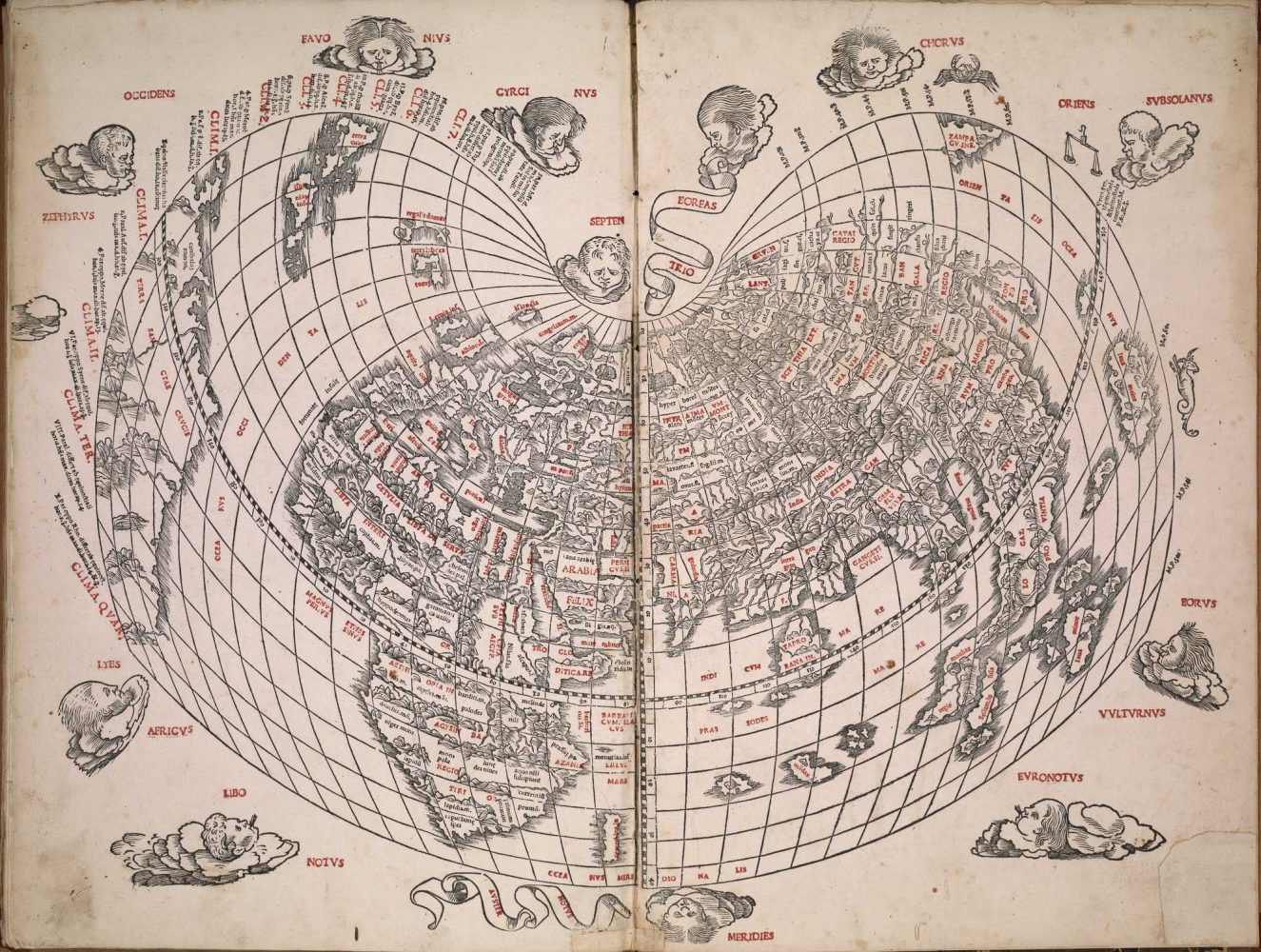
A cordiform world map, from Claudius Ptolemy, Liber geographiae cum tabulis et universali figura (Venice, 1511). Bell Call # 1511 oPt.
A similar type of cordiform, though slightly different in shape, comes from De Cosmographiae Rudimentis, by Johannes Honter (1498-1549). This particular edition was published in Basel in 1561 in a collection of other cosmographical and geographical texts. Honter was from Transylvania, and is credited with founding the Lutheran church there during the period of the Reformation. He was also an engraver, and carved the woodblocks for the original maps included in his work on geography. The maps were accompanied by verse, intended to help students remember the concepts and places. This cordiform map, first published some 20 years of Sylvanus’s, is more detailed with regard to the Americas, but note that Asia/India is still connected to the New World.
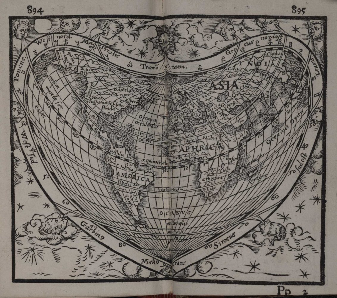
World map in the shape of a stylized heart, from a collection of geographical and cosmographical texts, including Johannes Honter, De Cosmographiae rudimentis (Basel, 1561). This small, readily portable book is about the size of a large hand. Bell Call # 1561 Pr.
Religious dissent may have also guided Oronce Finé (1494-1555) in the creation of a new type of cordiform map — the double-cordiform map, showing the northern (left) and southern (right) hemispheres, split at the equator. Finé was a mathematician, astrologer, philosopher, and theologian. He was arrested briefly in 1523, probably because he was suspected of heretical teaching at his university in Paris. The cartographic historian Jerry Brotton has argued that, “To make a heart-shaped map in the first half of the sixteenth century was a clear statement of religious dissent” [A History of the World in 12 Maps (Viking, 2012), p. 236]. This is because the symbolism of the heart shape automatically invited viewers to consider their own inner world and hidden emotions – “to look to their conscience.”
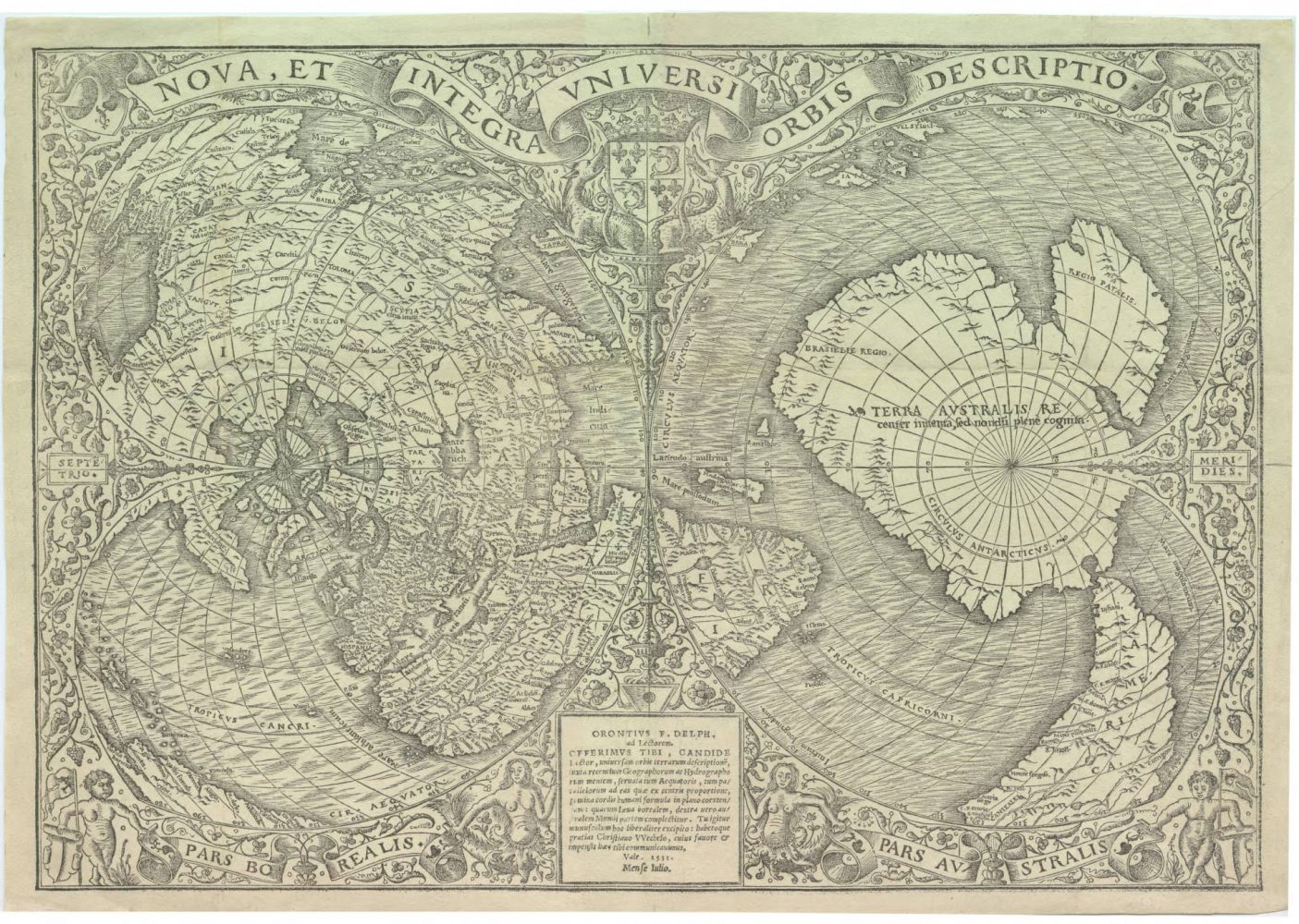
Oronce Fine, Nova, et integra universi orbis descriptio (Paris, 1531). Bell Call # 1531 mFi.
Quite apart from religious connotations, the map also depicts some of the most recent geographical discoveries of the early 16th century — in particular, a peninsula called “Florida” (close to center, left) described by Juan Ponce de León in 1513; and the South Pacific, here called “Mare Magellanicum” (close to center, right) indicating the first circumnavigation of the globe by members of the expedition led by Ferdinand Magellan.
The Spanish-born, Roman mapmaker Antonio Salamanca (1479-1562) follows the cordiform example of Finé, using the refined technology of copperplate engraving rather than a woodblock. The direct antecedent for Salamanca’s map, however, was another cordiform projection by Gerhard Mercator from 1538. Sadly, the Bell does not have a copy of Mercator’s version, but the Borchert Map Library at the U of M has a facsimile of it. Salamanca copied both Mercator’s sparer style, as well as some of the information on his map. Notably, Salamanca shows the Asian and American contents as divided by a body of water (though this would have been speculation in the 16th century) and labels most of the Americas as Spanish territory. It is interesting too that the Arctic, here connected to Greenland, is shown as an extension of the Eurasian landmass (left side, center).
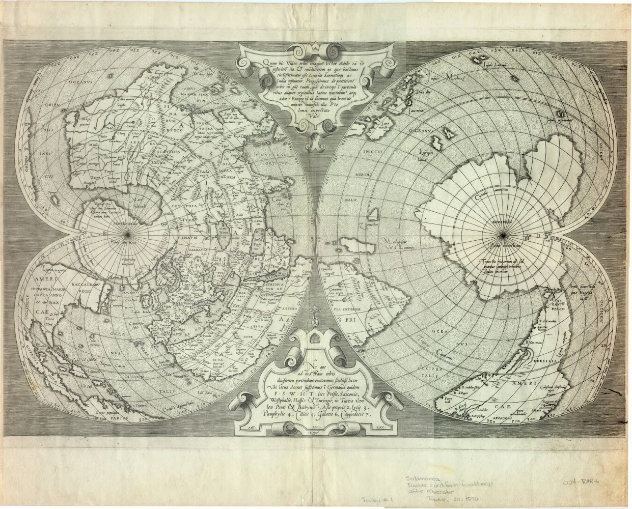
Antonio Salamanca, World map in double cordiform projection (Rome, 1550). Bell Call # 1550 mSa.
And finally, it wouldn’t be February without a love poem! Brotton and other scholars have pointed to John Donne’s “The good-morrow” as a literary work that surely refers to a cordiform map. Take a look at the second and third stanzas and see if you can discern the two halves of the world, two hearts, reflecting the connection of the lovers’ two souls.
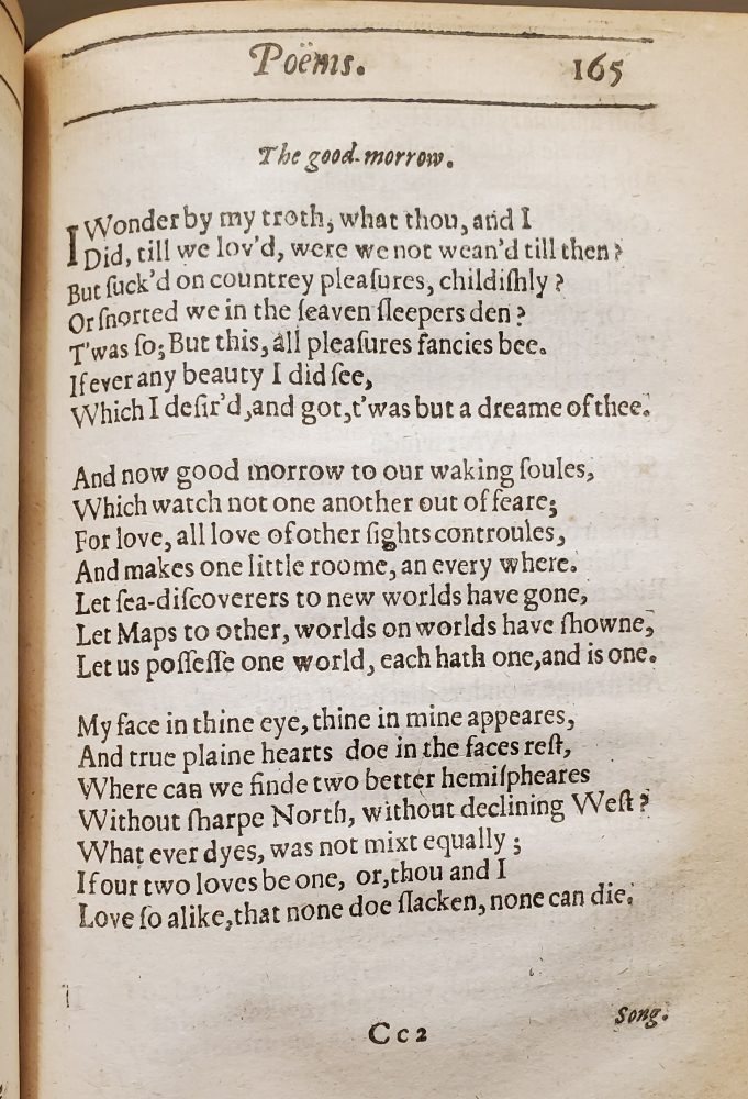
“The Good-Morrow” by John Donne, from Poems (London, 1633). Special Collections and Rare Books #823 D71 OPoM. Read the poem with modernized spelling here.